This paper describes a method for mapping and measuring the lands designated for growth and urban expansion in the area known as the Greater Golden Horseshoe under the provisions of the Growth Plan for the Greater Golden Horseshoe.
The Growth Plan was established in 2006 by the Province of Ontario to manage the rapid growth in the Greater Golden Horseshoe (GGH) shown in Figure 1, which includes 110 municipal jurisdictions: 10 single-tier municipalities, 11 upper-tier municipalities, and 89 lower-tier municipalities.
Figure 1: The Greater Golden Horseshoe
The Growth Plan contains many forecasts, policies, and targets; however two key elements in particular can be mapped and measured, because they contain specific numbers that can be used to assess whether municipalities are complying with the requirements of the Plan:
- 40 percent of all residential development each year is to be directed to already built-up urban areas in existing settlements (the target is lower in some municipalities) (Growth Plan, Section 2.2.3). Municipalities are required to track their achievement of this level of intensification starting in 2015.
- New development in Designated Greenfield Areas is to achieve a minimum density of 50 people and jobs combined per hectare (the target is lower in some municipalities) (Growth Plan, Section 2.2.7.2). This goal is to be averaged over upper- and single-tier municipalities; reporting requirements are not specified, although the Growth Plan mentions the importance of monitoring municipalities' implementation of this and other targets.
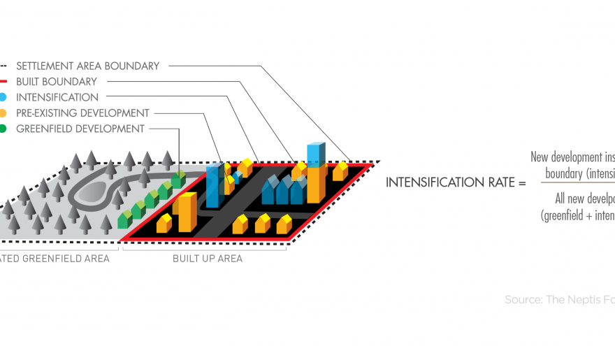
The implementation of the intensification rate target requires that the province, in consultation with each municipality, identify a Built Boundary for each municipality in the GGH. The Built Boundary is a fixed line that separates the existing built-up area within which new development is considered intensification from the Designated Greenfield Areas. Figure 2 illustrates this distinction. The Built Boundary is an important implementation and monitoring tool for the Growth Plan because it allows for the measurement of intensification and redevelopment within the built-up area and also allows new development outside the built-up area to be monitored.
Detailed mapping of the Built Boundary is available from the Ministry of Infrastructure.
Figure 2: Distinguishing the Built-up Area and the Designated Greenfield Area
In order to implement the Designated Greenfield Area density target, each municipality must identify the Designated Greenfield Area - the area planned for growth outside the Built Boundary and inside the Settlement Area Boundary (see Figure 3). These areas are important, because 60% of residential development is permitted to occur in these areas. Municipalities are also required to demonstrate that development on this land has been planned to achieve the required minimum density target (people and jobs combined per hectare).
Figure 3: Distinguishing the Built Boundary and the Settlement Area Boundary
Unlike the Built Boundary, the Settlement Area Boundary for each municipality was not determined by the Province and the Province does not make this information available to the public. Settlement Area Boundary information is found in municipal official plans, official plan amendments, and other planning documents from the many municipalities in the GGH. Moreover, the Province has not provided a uniform method or standard for defining a Settlement Area Boundary, so the approaches taken by municipalities to creating land use mapping in official plans vary considerably from municipality to municipality.
The Neptis Foundation, therefore carried out independent research to identify and map the location of each Settlement Area Boundary and to calculate the amount of land lying between the Built Boundary and the Settlement Area Boundary. This exercise was the first attempt to determine the total amount of land set aside for development up to 2031 throughout the entire GGH under the provisions and through municipal implementation of the Growth Plan.
Furthermore, as of 2006 some municipalities had already designated enough land to accommodate the forecast growth to 2031; in other cases, municipalities designated additional lands needed after 2006 to accommodate growth. Neptis researchers also distinguished between land designated before the Growth Plan came into effect in 2006 and land designated after that time.
This document describes the methods and sources of information used to define and map the Settlement Area Boundary and to measure the amount of land contained within the Designated Greenfield Area of each municipality.


