As we approach the 10-year review of the Growth Plan for the Greater Golden Horseshoe, there are usually two broad questions being asked about "land" as it relates to long-term planning and how the region will grow.
- What is the current supply of land designated for future urban development and where this land has been designated?
- How fast is the current supply being used up, how much of it remains, and where is the remaining land?
Two years ago, Neptis researchers answered the first question in the landmark report "Implementing the Growth Plan for the Greater Golden Horseshoe."
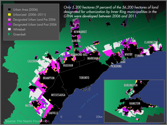
The authors looked at municipal Official Plans and found that 107,100 hectares of land have been designated for urbanization across the Greater Golden Horseshoe since the implementation of the Growth Plan.

Of this total, 56,200 hectares lie within the Inner Ring, that is, the Greater Toronto and Hamilton Area (GTHA). The other 50,900 hectares, almost half the total land supply, lie in the Outer Ring, beyond the Greenbelt, even though the Outer Ring is expected to attract only one-third as many new residents and one-quarter as many jobs as the Inner Ring.
Neptis researchers now have insight into the second question, and have calculated the amount of land that has actually been built on between 2006 and 2011 in the Greater Toronto and Hamilton Area (the Inner Ring). Similar information is not yet available for the Outer Ring.
The research shows that of the designated urban land in the GTHA, only 5,200 hectares (9 percent) of the 56,200 hectares of designated land supply in the Inner Ring have been urbanized.
Enough land remains in the current supply to last to 2031 and likely beyond.
Knowing how much land has been developed in that five-year period provides a clearer picture of how long the currently designated land supply will last.
It also provides context for discussions on Amendment 2 to the Growth Plan. This amendment extended the population and employment projections to 2041 and forecast a population of 13.5 million people and 6.3 million jobs in the Greater Golden Horseshoe by that date.
The process of designating even more land to accommodate the new projections has begun in some municipalities, but this work is not yet complete.
Knowing the rate at which land is being consumed helps us understand whether we need to designate even more land - given the sizable amount that is already available.
Neptis has also prepared a discussion paper explaining the key features of the Growth Plan for the Greater Golden Horseshoe in order to contribute to the 10-year review of the Plan.
The paper highlights questions surrounding its implementation, and presenting evidence on its results to date.
This discussion paper answers three questions: (1) How does the Growth Plan for the Greater Golden Horseshoe work? (2) Is the region running out of land for development? (3) Have development patterns changed since the Plan was established?
You can read the full brief as a PDF, download it or read it on the website as chapters by following the links.
