Here's a partially good news story about urban sprawl.
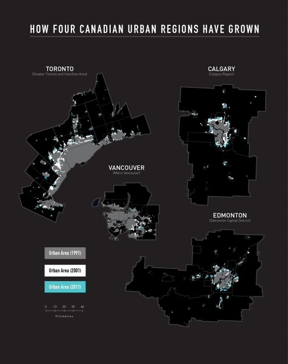
Preliminary findings from the Neptis Foundation showing how four major Canadian cities have grown in the past 20 years indicate that while the populations of the Vancouver, Edmonton, Calgary, and Toronto city-regions continue to expand, the rate at which new land is being urbanized at the edge has decreased over time - sometimes quite dramatically.

Expanding on the original analysis of the 2010 report Growing Cities,[1] the time frame of the new analysis covers two decades, 1991-2001 and 2001-2011.
Although most new residents since 2001 continue to settle in suburban areas in three of the four cities (Calgary, Edmonton, and Toronto), all Canadian cities have been growing more densely at their edges,[2] even as residential intensification in already built-up areas continues.
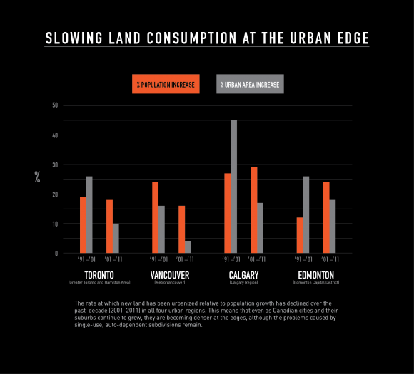
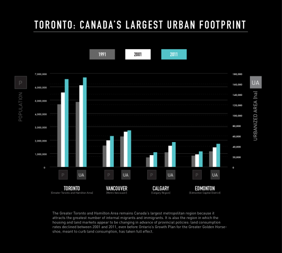
The growth of the Greater Toronto and Hamilton Area (GTHA), the largest metropolitan region in Canada, tells a particularly interesting story. Its population increased by 19% to 5.6 million people from 4.7 million in the first decade (1991-2001) and by 18% to 6.6 million people in the second (2001-2011). But the rate of urban land consumption to accommodate new residents was 26% in the first decade and dropped to only 10% in the second.
A similar trend, albeit to varying degrees, repeats itself across the other metropolitan areas. Vancouver's population increased by 16% between 2001 and 2011, while its urban area increased by only 4%. Vancouver is the only city-region of the four studied where the majority of the new population was mostly accommodated within the existing urban area rather than the expanding urban edge. This finding may be expected in a city that has long had urban growth controls in place.
What is more surprising is that in Calgary, where it was only in 2009 that planning policies shifted toward greater densification and intensification, the rate of urban expansion dropped to 17% in the second decade, from 45% in the preceding decade while the population increase stayed relatively the same (29% between 2001 and 2011 and 27% between 1991 and 2001).
In Edmonton, the story is slightly different. The population increased by 24% and the urban area by 18% between 2001 and 2011, compared with a population increase of 12% and an urban area increase of 26% between 1991 and 2001.
These findings suggest that the urban expansion of these four cities no longer constitutes "sprawl," commonly defined as the process whereby municipalities expand outward at a faster rate than the increase in population.

In the Toronto region, the decrease in the rate of land consumption at the edge of the region's Inner Ring (the GTHA)[3] comes at a time when the implementation of the 2006 Growth Plan for the Greater Golden Horseshoe is still in an early stage. The slowing of land consumption at the urban edge therefore cannot be considered a direct outcome of the Plan's policies.
In the Toronto context, these preliminary research findings lead us to ask three questions.
First, are the policies in the Growth Plan intended to slow land consumption lagging behind market trends?
Second, if land consumption is slowing, why has such a large area been designated for development through the Growth Plan implementation process?
And finally, are policies that attempt to rein in "sprawl" (defined in this very basic way) the most effective means to achieve the goals of the Growth Plan?

If, as our preliminary analysis shows, the rate of urban expansion at the edge is slowing down even before policies such as the Growth Plan have taken full effect, then it is reasonable to ask whether government efforts to prevent sprawl could have been more ambitious.
Although the Growth Plan seemed progressive at the time, researchers such as Chris Nelson at the University of Utah argue that today's cities and suburbs are being shaped by the housing and lifestyle choices of retiring baby boomers and millennials, who are creating a greater demand for transit-oriented development in mixed-use communities.[4] His work, like ours, suggests that the Growth Plan may be lagging behind market trends that call for a more holistic approach to community-building, focusing on more than simply density targets and land consumption rates.
Moreover, if government policy is lagging behind market forces, have municipalities over-designated land for urbanization based on the less-ambitious government targets?
A 2013 Neptis report about the implementation of the Growth Plan for the Greater Golden Horseshoe suggested that the entire region has designated more than enough land for urban expansion. Municipalities throughout the region have set aside 1,071 square kilometres (107,100 hectares), an area more than one and a half times the size of the City of Toronto, to accommodate the 3.7 million people who are expected by 2031.
The report noted that the amount of land represented largely business-as-usual land consumption rates. If land consumption is slowing, municipalities may find that they have set aside more land than they need to accommodate their growing populations. Certainly, these preliminary findings support the earlier report's conclusion that it would be premature to designate further lands for urbanization, including the lands known as the "Whitebelt" that lie between the Greenbelt and the greenfield expansion areas in the GTHA.
Finally, we must consider whether reining in "sprawl" simply by setting density targets and requiring land budgets for new development is the solution to problems that continue to plague suburban municipalities - traffic congestion, difficulties in implementing cost-effective transit networks, and a lack of diversity in land use that prevents the formation of "complete communities."

After all, although Canadian cities have already been shown to develop more densely than their American counterparts, they continue to face challenges associated with single-use, auto-dependent subdivisions. This is one reason why the Toronto region continues to suffer from ever-worsening traffic congestion.
Pierre Filion at the University of Waterloo has observed that even as some suburbs grow denser, they continue to function like lower-density areas in terms of traffic congestion and low levels of transit use. David Gordon at Queen's University has documented similar trends in Canadian cities.
To summarize: we have found a disconnect between long-term projections under the Growth Plan to urbanize land, in the form of density goals and land budgets, and the current reality of how Canadian cities are growing on the edge.
During the period leading up to the mandatory ten-year review of the Growth Plan in 2016, it is important to consider whether, because of unambitious targets in the Plan itself, municipalities in the Greater Golden Horseshoe are designating more land for urbanization than the market would otherwise dictate.
The Neptis Foundation is preparing a more detailed analysis of 20-year growth trends at the urban edge and intensification in existing built-up areas, due out in fall 2014.
