Neptis researchers reviewed the Official Plans of municipalities across the Greater Golden Horseshoe and found that approximately 107,100 hectares (1,071 square kilometres) have been designated for future urbanization by municipalities in the region as a whole.
It is important to note that about 88,000 hectares or 80 per cent of the total had already been designated for urbanization even before the Growth Plan came into existence. The remainder was added as part of the land budgeting process. This leads some to argue that the potential for business-as-usual development is great because the Plan was already compromised at its start with so much land already in the pipeline; while others say that the relatively small amount of land set aside for future expansion shows the Plan is working.
Where has the land been designated?
Here's how this total breaks down:
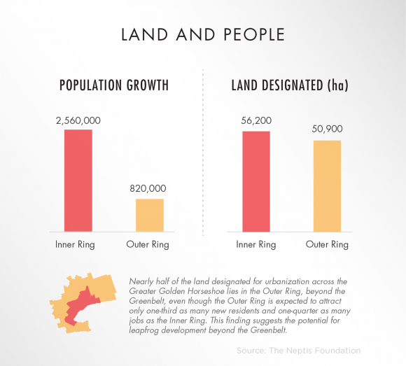
Inner Ring: 56,200 hectares
Outer Ring: 50,900 hectares

Nearly half of the land designated for urbanization across the Greater Golden Horseshoe lies in the Outer Ring, beyond the Greenbelt, even though the Outer Ring is expected to attract only one-third as many new residents and one-quarter as many jobs as the Inner Ring. This finding suggests the potential for leapfrog development beyond the Greenbelt.
It also means that the Outer Ring municipalities, many of which do not offer transportation alternatives to the private automobile and do not have well-developed water, sewer, and other infrastructure, will be permitted to reproduce the kind of low-density, car-oriented development patterns that have led to problems in the Inner Ring.
When will land designated for urbanization be developed?
This supply of land is meant to accommodate population growth up to 2031. As a result, the region is now planned to 2031. The land designated for urbanization will never be "unzoned."
But the type of housing that goes into these 2031 lands can be rethought and policy changes to create a more diverse housing stock can still happen.
There is usually a time lag between the designation of land for urban use and the time that land is serviced with sewer, water pipes, and other infrastructure and ultimately built upon. In some cases the lag can last for more than a decade, so it is not readily apparent to residents that an area has been designated for urban use.
A time lag for the implementation of the Growth Plan can also occur because of the appeal of a municipal Official Plan to the Ontario Municipal Board. Because of these delays, almost ten years after the Growth Plan was established, there are still many municipalities where the Growth Plan is not yet in effect. The Province is currently considering new rules that will extend the review of new municipal official plans to 10 years, instead of the current five-year cycle, and limit appeals to the OMB.
Although a municipality may have created a land budget and proposed changes to its Official Plan to reflect the Growth Plan targets, these updated Official Plans are not yet in force if they are appealed to the OMB. The consequences of this time lag may lead to planning decisions that run counter to the intent of the Growth Plan.
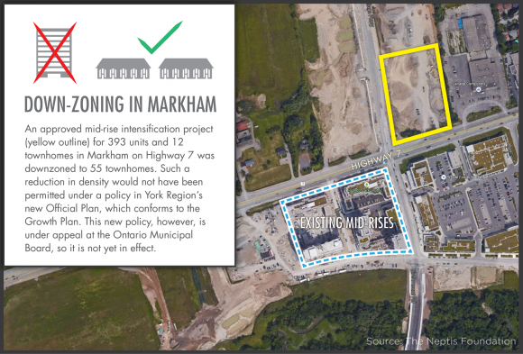
For example, in Markham on Highway 7, a controversial proposal for a mid-rise condo and townhouse units opposed by area residents went to the Ontario Municipal Board after council failed to make a decision on the matter. A settlement between the City of Markham and the developer at the Board allowed for three mid-rises of 393 units and 12 townhomes, but the developer later downzoned the application to one for 55 townhouse units. It is worth noting that there are other mid-rise condos on the same road and a shopping mall just across the street. A York Region planner was quoted in Novae Res Urbis saying that there is a policy in York Region's new Official Plan that would have prevented such downzoning outside a comprehensive review, but the policy is under appeal at the Ontario Municipal Board so it is not in effect. [1]

What is Amendment 2?
There is also the issue of Amendment 2 to the Growth Plan introduced by the Province in 2013. This amendment forecasts another 2 million people in the region by 2041. As noted earlier, this essentially extended the life of the Growth Plan for another decade from 2031 to 2041.
Amendment 2 provides an opportunity to make a difference, because although the population has been directed to the upper- and single-tier municipalities, the land budgeting process has not yet been completed. This provides for an opportunity to make the land budgeting process more transparent and to take a more strategic approach aligning population with existing infrastructure such as sewers, water, roads and transit.
The Province claimed that the 2041 forecasts were needed to ensure a 20-year supply of land for development. In fact, the Provincial Policy Statement has traditionally required municipalities to maintain a land supply of "up to" 20 years, which some argue can be considered a maximum, not a minimum. Extending the forecasts to 2041 (more than 25 years away from now), means that the process of setting more land aside will begin before the effectiveness of Growth Plan policies are known.
[1] Novae Res Urbis, 3rd December 2014: Downzoning in Markham
