Latest

Planning the Next GGH explores the implications of this shift and raises raises critical questions about planning for an increasingly dominant single centre which is under intense growth pressure and what it means for an extended Toronto region (GGH).

The latest release of the Neptis Geoweb marks the third iteration of a powerful, analytical tool that provides detailed regional planning information and mapping to visualize the forces shaping the Toronto region.

Marcy Burchfield, Executive Director of the Neptis Foundation is one 16 thought leaders across the Greater Toronto and Hamilton Area who were invited by the Institute on Municipal Finance & Governance (IMFG) to contribute Bold Election Ideas for the Toronto Region.The short pre-election papers were commissioned to ask questions - often uncomfortable questions - about the places we live and the environment we are creating for those who live here. Burchfield's contribution focuses on the critical need for a formal mechanism of coordination and collaboration among area municipalities, without which there is a risk that municipalities in the GTHA will default to parochialism if the Province loses interest in being the de facto regional planner.

Marcy Burchfield, Executive Director, was invited to the Toronto Region Board of Trade's Distinguished Speaker Series to discuss the five reccomendations in their housing policy playbook which aim to increase housing supply by adding the right type of housing to close to transit.

Marcy Burchfield, Executive Director of the Neptis Foundation appeared on the TVO news show The Agenda on Friday, April 6, 2018 to discuss the demise of the Ontario Municipal Board and its replacement by the Local Planning Appeal Tribunal (LPAT).

Marcy Burchfield, Executive Director of the Neptis Foundation was recently asked to moderate a panel (Growing up Green, Not Greenfield) at Environmental Defence Canada's Smart Communities Lab Conference. Before the panel discussion. Burchfield gave a presentation titled Understanding Growth & Change in the GTHA. The presentation, which we have posted below, provided an overview of Neptis research, providing a context for long-range regional plans, demographic trends, and historical growth patterns that form the backdrop for the region's transition to a new model of growth.
Marcy Burchfield, Executive Director of the Neptis Foundation, was recently invited to a forum in Quebec City to share Neptis research and my knowledge of the Ontario land use planning system with more than 100 civil society representatives advocating for a provincial policy for land use and urban planning to address societal challenges in Quebec. Here is her account of the forum.


Pamela Blais, a city planner and principal of Metropole Consultants and Marcy Burchfield, executive director of the Neptis Foundation wrote a commentary published in the Toronto Star. The commentary examines why Metrolinx's updated $45 billion draft Regional Transportation Plan fails to deliver on the key measure of shifting people away from automobiles on to transit, and what can be done to address the problem.

New research for the Neptis Foundation shows that the Tor-York West and Tor-York East employment megazones - two large suburban employment areas in the Greater Toronto Area - have significant potential to create attractive and transit-supportive urban space for tens of thousands of new office workers.
These areas represent sizeable clusters of jobs, and have proved resilient during recent economic changes. Although both areas lost manufacturing jobs between 2001 and 2011, in Tor-York West, the losses led to an overall decline of only 0.4% in core employment (less than the decline for the region as a whole), while Tor-York East succeeded in attracting new finance and business services jobs to compensate for the losses, resulting in a 9% gain in total core employment. Such important economic assets need to be recognized in provincial and regional plans, but the megazones have long been ignored.
Changes in both megazones reflect broader economic trends in the region as its transition to a more knowledge-centred economy. "The growth of knowledge-intensive work is one of the key dynamics reshaping the employment geography of the Toronto region," says Pamela Blais, who conducted the research. "This change presents a significant opportunity to create denser, more attractive, more competitive employment districts in suburban megazones that can be better served by transit."

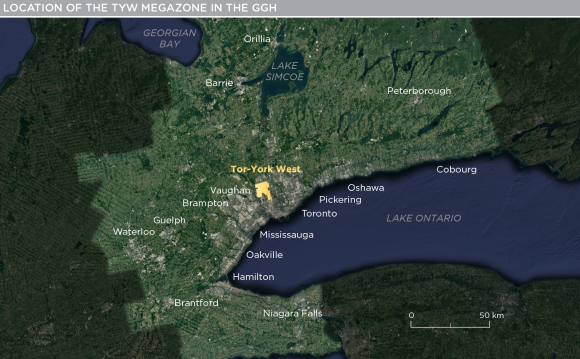
This Policy Brief defines and describes the Tor-York West megazone (TYW), one of three regionally, provincially, and nationally significant employment zones identified in the Neptis Foundation report Planning for Prosperity.
TYW covers a large area in the City of Vaughan and the City of Toronto. Of the megazone's approximately 140,000 jobs, 45,000 are in manufacturing, and more than 11,000 in construction, making this the region's workshop. More than 20,000 jobs are in wholesale trade and transportation - not surprising, given the presence of a CN multimodal facility. There are also almost 20,000 jobs in finance and business services.

This Policy Brief defines and describes the Tor-York East megazone (TYE), one of three regionally, provincially, and nationally significant employment zones identified in the Neptis Foundation report Planning for Prosperity.
The TYE megazone surrounds the interchange of Highways 404 and 407, including parts of the cities of Markham, Richmond Hill and Toronto. It contains approximately 106,000 jobs, many of them in tradeable goods and services.
